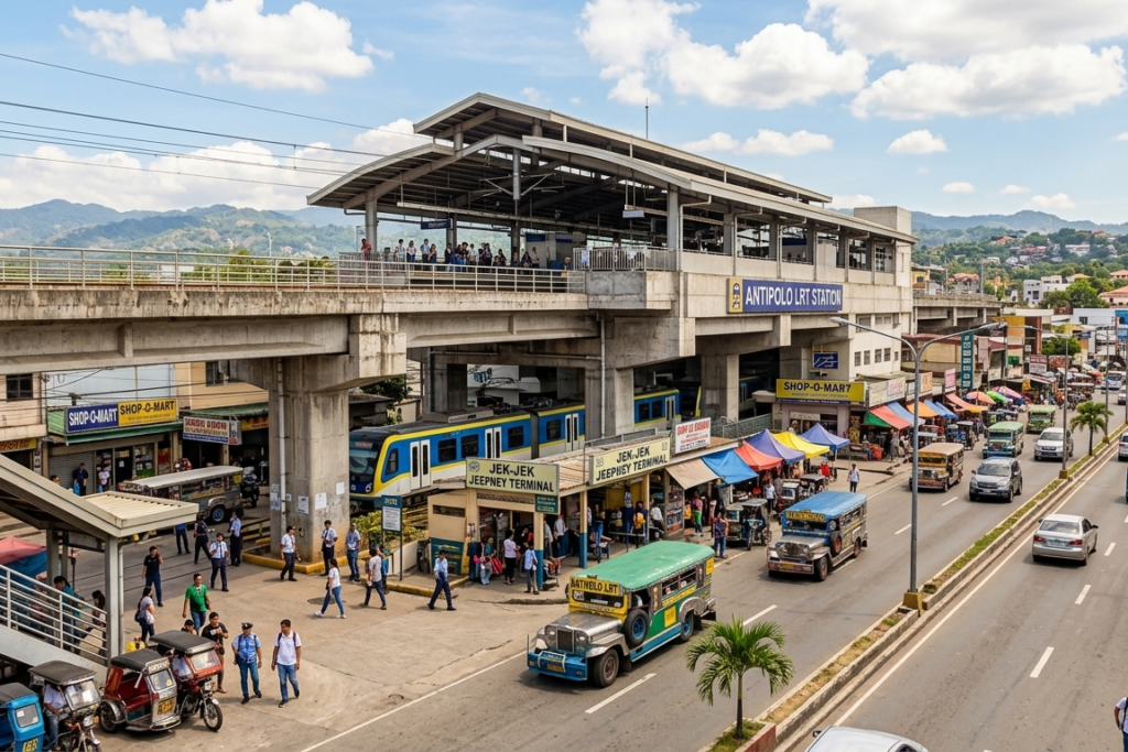
Transit logic for commuters arriving at or departing from the three easternmost LRT-2 stations: Antipolo (Masinag), Marikina–Pasig (Sta. Lucia), and Santolan. Covers onward transport, local jeepney and tricycle connections, and how to navigate deeper into Rizal province or central Marikina.
Antipolo–Marikina Area city guide provides:
- Walking Path and Transfer Points
- Transit Modes, Terminals, Fares, Routes
- Important Sites & Street-Level Access
- Local Mode and Return Logic
Navigate the LRT-2 East Extension. Guides for SM Marikina, Masinag Hub, and the Antipolo uphill jeepney routes. Master the East-Metro commute.
☎️ 7890 (Action Center Hotline) Department of Transportation (DOTr) → For public transportation services and passenger complaints.
Key Takeaways
- The “Mall-to-Platform” Link At the Marikina-Pasig Station, you have direct, indoor footbridge access to SM City Marikina and Robinsons Metro East.
Use these malls as your “staging area” for air-conditioned waiting. - The “Antipolo Loop” Logic From the Masinag Station, transport is split:
- Up-hill: Toward Antipolo Cathedral/Upper Antipolo.
- Down-hill: Toward Cogeo/Padilla
- The Marikina-Pasig Station is built high for a reason. During heavy rain, the Marikina River can swell. The station remains operational, but the jeepney routes below (to Marikina Proper) may be diverted or suspended.
- The Marcos Highway Walkway: The Path: SM Marikina ➡️ Marikina-Pasig Station ➡️ Robinsons Metro East ➡️ Ayala Malls Feliz.
- Operational Note: This is the most modern “Mall Crawl” in the East.
- Navigation Hint: Stay on the elevated footbridges along Marcos Highway. The ground level has heavy truck traffic and narrow sidewalks.
Antipolo-Marikina: The East Gate “Elevation Gap”
The LRT-2 East Extension, which has transformed Masinag and Marikina-Pasig into the primary “climbing” points for the Sierra Madre foothills. Primary Anchors: Antipolo (Masinag) Station (East Terminal) and Marikina-Pasig Station (The Mall Link).
“The Katipunan Backdoor”
- If the LRT-2 has a service interruption, don’t wait for a bus on Marcos Highway. Take a “Marikina-Pasig” trike to the Riverbanks Center, then take a jeepney to Katipunan. From there, you can access the rest of Quezon City much more easily.
Station 1 — Antipolo (Eastern Terminus)
Marikina–Infanta Highway at Sumulong Highway junction · SM City Masinag attached
- Jeepneys
- Board along Marikina-Infanta Highway outside the station. Confirmed routes:
- Marikina-Paenaan, Cogeo-Cubao via Marcos Highway.
- Jeepney to Cogeo departs from this junction every 10-15 minutes.
- East Gate Terminal
- East Gate Business Center and Terminal Center – 3-5 min walk from station via covered walkway. Has buses, e-jeeps and tricycles to Padilla-Paenaan and deeper Antipolo city proper
- Sumulong Hwy
- Jeepney toward Antipolo city proper via Sumulong Highway boards near the Masinag juction outside the station.
- Passes Cloud 9 area, Circumferential Road, and goes further up towards Antipolo Cathedral and downtown Antipolo
- Antipolo City Proper
- Tricycle or jeepney from East gate terminal to Antipolo city center. Tricycle is faster for direct trips to subdivisions (Golden Meadows, Kingsville, Filinvest East, Vermont Park). Confirm exact fare on-site
- Key Landmarks
- SM City Masinag (attached), Cornel Medical Center, Metro Antipolo Hospital, Diocesan Shrine of St. Therese of the Child Jesus, Pinto Art Museum is 20 min by tricycle or Grab. Cloud 9 Antipolo is 10 min by ride
Station 2 — Marikina–Pasig
Gil Fernando Ave / Felix Ave intersection, San Roque, Marikina · Sta. Lucia / Robinsons Metro East area
- Nearby malls
- Sta Lucia East Grand Mall and Robinson Metro East are the two anchor malls at this station.
- Both are walkable from the station exits.
- Jeepney and tricycle terminals outside both malls
- SM City Marikina
- SM City Marikina is 1.2 km from this station – approximately 6-minutes jeepney ride or 15-min walk.
- Jeepney run frequently between this station and SM Marikina / River banks Center
- Jeepneys
- Jeepneys at Sta Lucia and Robinsons Metro East serve routes towards Cubao (via Marcos Highway), Cainta, Taytay and Pasig. Confirm signboard before boarding – multiple routes overlap at this section
- Residentials Areas
- Serves San Roque Marikina, Cainta, Rizal and Sta Lucia area
- Near the tripoint boundary of Metro Manila (Pasig / Marikina / Rizal)
- Tricycle serve barangay-level destinations
Station 3 — Santolan (Marikina)
Marikina–Infanta Highway, Calumpang, Marikina · Only island platform on LRT-2 · Only one entrance
- One Entrance Only
- Santolan has a single entrance – directly across the Uratex Marikina Showroom. Unlike other stations, you cannot enter from both side of the highway, use the footbridge to cross over
- Transport Nearby
- Jeepney and tricycle nearby SM City Marikina and Riverbanks Center are the primary landmarks – both about 2.8 km away (more frequent jeepney connections to these here than at Marikina-Pasig Station). Closer to Marikina Sports Complex.
- Island Platform
- Santolan is the only LRT-2 station with an island platform – both eastbound and westbound trains use the same central platform. If you arrive here and are unsure of direction, check the train signboard carefully before boarding.
- LRT-2 Depot
- The LRT-2 operations control center and Santolan Depot (train maintenance facillity) are located besides this station. This is where the trains return at the end of service and where breakdown-related interruptions often originate or are maintained.
LRT-2 Fares and Hours
- Beep card (stored value) — end to end
- ₱33
- Recto ↔ Antipolo · minimum ₱14
- Single journey ticket — end to end
- ₱35
- Recto ↔ Antipolo · minimum ₱15
- Student / Senior / PWD discount
- 50% off
- Concessionary beep card required · increased from 20% in 2025
- Per km rate
- ₱1.21 / km
- Added above minimum boarding fee
- First trip (both ends)
- 5:00 AM daily (updated Jan 1, 2026)
- Last trip from Antipolo
- 9:00 PM · do not cut close
- Last trip from Recto
- 9:30 PM daily
- End-to-end travel time
- ~35–40 min (normal operations)
Key onward routes from the eastern corridor
- Eastern corridor → Cubao / Quezon City
- LRT-2 westbound from any of the three stations. Alight at Araneta Center–Cubao. Transfer to MRT-3 via Gateway Mall walkway if continuing south. Approx 15–25 min from Antipolo Station to Cubao.
- Eastern corridor → Makati / BGC
- LRT-2 westbound to Cubao. MRT-3 southbound to Ayala (Makati) or Guadalupe (BGC connection). Or LRT-2 all the way to Recto then LRT-1 southbound — longer but cheaper if staying on rail.
- Eastern corridor → Manila (Quiapo, Ermita, Tondo)
- LRT-2 westbound to Recto Station. Recto is directly connected to Quiapo, Divisoria, and the university belt. For Malate and Ermita, transfer at Doroteo Jose to LRT-1 southbound.
- Antipolo Station → Cogeo / deeper Antipolo
- Jeepney from Masinag junction (outside station) toward Cogeo. Departs approximately every 5 minutes. Journey to Cogeo takes ~22 min. For Antipolo Cathedral and downtown, take jeepney via Sumulong Highway from East Gate Terminal.
What to know before you go
- The LRT-2 schedule changed on January 1, 2026 — first trips from both ends now depart at 5:00 AM. Previously, Antipolo’s first trip was later. Older guides may show the old schedule. Confirmed current.
- The concessionary discount increased from 20% to 50% in 2025 for students, senior citizens, and PWDs. You need a concessionary beep card — a special white card issued at any LRT-2 station ticket booth with valid ID. Regular beep cards do not apply the discount automatically.
- Antipolo Station does not have a traditional ground-level terminal — the East Gate Business Center Terminal is the organized transfer point. It is a 2–3 minute walk from the station via a covered walkway. If you exit and see SM City Masinag, you are on the right side. If you cannot find the terminal, ask any station guard — it is clearly known to staff.
- The proposed LRT-2 extension further east to Cogeo is still in feasibility study as of early 2026. Do not plan travel around it — it has no confirmed construction start date. The current Antipolo Station remains the terminus.
- Santolan’s single entrance is a common confusion point for first-time commuters. There is no second entrance on the other side of the highway. If you exit on the wrong side, use the pedestrian footbridge — it is there specifically for this reason.
- LRT-2 is the least crowded of Metro Manila’s three rail lines, but rush hour (7–9 AM eastbound, 5–7 PM westbound) still creates queues at Antipolo and Marikina–Pasig platforms. Arrive a few minutes early if catching the last two trains of the evening.
Important Sites & Street-Level Access
Educational & Training Hubs
- Marikina Proper (Sta. Elena)
- Location: Marikina Proper (Sta. Elena).
- Access: Ride a “Marikina/Bayan” labeled jeepney from the ground level of the Marikina-Pasig Station
- Ateneo de Manila / Miriam College / UP Diliman
- Location: Katipunan Ave.
- Access: Ridethe LRT-2 Westbound to Katipunan Station (3-4 stops away). This is the fastest “Student Commute” in the East.
Recruitment & BPOs
- SM Marikina / Bridgetowne BPO Clusters
- Location: Marcos Highway and C-5.
- Access: Walk from Marikina-Pasig Station for SM Marikina.
- For Bridgetowne (Accenture/Concentrix), take a “Pasig/Junction” jeepney from the station
Shopping & Nightlife
- Antipolo Cloud 9 / Sumulong Nightlife
- Location: Sumulong Highway.
- Access: Ride an “Antipolo/Sumulong” jeepney from the Masinag Station. This area is famous for “Overlooking” restaurants and views of the Manila skyline.
- SM City Masinag
- Location: Marcos Highway cor. Sumulong Highway.
- Access: Direct Access via the Antipolo (Masinag) LRT Station footbridge.
Medical & Government
- Marikina Valley Medical Center
- Location: Sumulong Highway cor. Gil Fernando Ave.
- Access: Walk from the Marikina-Pasig Station (approx. 8 mins) or take a short trike ride
- Antipolo City Hall (Annex)
- Location: Near the Masinag intersection.
- Access: Walkable from the Masinag Station.
Antipolo-Marikina The “Cogeo” Jeep
- The Cogeo Hub: Located at the Masinag intersection. These jeeps are the “mountain climbers” of the East, taking passengers deep into the Sierra Madre foothills and Rizal province.
- Trike Zones: Marikina is famous for its organized trike system. Fares are standardized by the LGU. Always look for the fare matrix posted inside the sidecar.
The Exit Strategy
- To Manila (Recto/Quiapo): Head to the LRT-2 Westbound (any station). It is the only way to bypass the Santolan/Marcos Highway bottleneck.
- To Makati/BGC: Head to Marikina-Pasig Station. Take a “UV Express” labeled “Ayala” or “BGC” from the Robinsons Metro East terminal.
- To Quezon City (Cubao): Take the LRT-2 Westbound to Araneta Center-Cubao Station.
⚠️If you’re unfamiliar with the area, first-time in Manila, or want to understand how the system works before moving, you’ll get more value from PH Commute 101: First 24 Hours in Manila.
Travel smarter, use Commute Guides links as your tool to understand how modes connect before moving.
Choose your intent. Navigate with confidence. Move without guessing. Use Homepage as your control panel.
Places worth imagining—before you ever arrive, explore Dream Destinations for your weekend getaways and travel itineraries
MappedAtlas improves with commuter reports. If you find outdated routes, changed timetables, or new paths, send a quick update.
Last updated: March 2026
Disclaimer: The information here is for guidance only. Schedules and fares are subject to change based on traffic, weather and maintenance without notice from the operators. Always allow extra time for your trip. Safe travel “Ka-Atlas”.