Sampaloc-Avenida City Guide: Navigating the Academic Heartland of Metro Manila
Step-by-step navigational guide around U-Belt of Sampaloc Metro Manila. Navigating the U-Belt is best understood not as a single hub, but as a grid of parallel corridors that must be traversed to reach dozens of specific schools, bus terminals, malls, training & review centers, government agencies and transient houses.
MappedAtlas Sampaloc-Avenida city guide provides:
- Walking Path and Transfer Points
- Bus Terminals → Operators → Schedules → Fares → Routes
- Important Sites & Street-Level Access
- Local Mode and Return Logic
Primary Anchor: Intersection of España Blvd and Nicanor Reyes St. (Morayta).
Key Takeaways
- The “Morayta Pivot”
- Most transit flows through the Morayta-España corner.
- The Walking Rule
- If your destination is within 800 meters (e.g., FEU to UST), walking is always faster than taking a jeepney due to the “U-turn” traffic logic on España
- Flood Warning
- Avoid España, P. Noval, and Lacson during heavy rain. Use the LRT-2 Legarda line as your high-ground escape.
Sampaloc-Avenida Bus Terminals, Routes, Fares, Operators and Schedules
These are older hubs often used by students and residents of Manila proper.
These terminals are located in the “University Belt” (U-Belt). On Fridays and holidays, they are packed with students heading home to the North.
- Zone A: Avenida (The LRT-1 Hub):
- Terminals: Philippine Rabbit, JAC Liner, Genesis.
- Access: Use LRT-1 Doroteo Jose Station.
- The terminals are a 2-minute walk from the station exit.
- Zone B: Sampaloc (The LRT-2/España Hub):
- Terminals: Fariñas, GV Florida, Partas.
- Access: Use LRT-2 Legarda Station (then a short tricycle/jeep ride) or head to the España/UST area.
- Pro Tip: This area is prone to flooding during the rainy season.
| Destination | Bus Line | Terminal Location | Class / Vibe | Fare (Est.) |
| Laoag City | Fariñas Transit | M. dela Fuente St. | Super Deluxe (CR/WiFi) | ₱1,000 – ₱1,200 |
| Tuguegarao | GV Florida | AH Lacson Ave. | Sleeper Class (Beds) | ₱1,100 – ₱1,400 |
| Vigan City | adept | Aurora Blvd (Sampaloc) | Luxury / First Class | ₱800 – ₱1,100 |
| Baguio City | Philippine Rabbit | Avenue (D. Jose) | Regular / Deluxe | ₱600 – ₱850 |
| Banaue (Ifugao) | GV Florida | AH Lacson Ave. | Tourist Deluxe | ₱850 – ₱1,000 |
| Pushing | GV Florida | AH Lacson Ave. | Executive Deluxe | ₱1,200 – ₱1,500 |
| Lucena City | JAC Liner | Avenue (D. Jose) | Regular AC | ₱300 – ₱350 |
| Pangasinan | Five Star | Avenue (D. Jose) | Regular AC | ₱450 – ₱600 |
☎️ tel:7890 (Action Center Hotline)Department of Transportation (DOTr) → For public transportation services and passenger complaints.
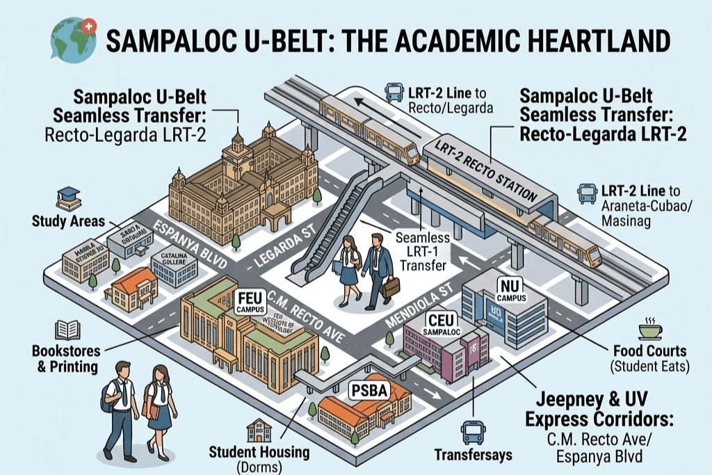
University Belt Sampaloc-Avenida city guide walking path and transfer points
Navigating the Corridors is the fundamental route logic needed to traverse the dense Sampaloc University Belt. The key is understanding the three parallel corridors and their transfer points.
| Corridor | Logical Action | Main Streets | Mode (Logic) | Key Signage to Check |
| Taft Corridor (North-South) | INITIATE (Primary mover) | Taft Avenue / Rizal Ave | LRT-1 (Fastest) / Jeepney (Cheapest) | “Rizal Ave” / “Monumento” / “LRT” |
| Espanya Corridor (Diagonal) | TRANSITION (Secondary corridor) | Espanya Blvd / Nicanor Reyes | Jeepney / UV Express (Direct to U-Belt) | “Espanya” / “Mendiola” |
| Recto Corridor (East-West) | PENETRATE (Last block) | C.M. Recto Ave / Legarda St | LRT-2 (Fastest) / Tricycle (Point-to-Point) | “Recto” / “Legarda” |
The Primary Mover – LRT 1
Your primary goal is to move North into Sampaloc. The fastest way to initiate this is by using the LRT-1 along Taft Avenue.
- Logical Nodes:
- You must transfer at one of two specific stations: LRT-1 Carriedo Station or LRT-1 D. Jose Station.
- These are your crucial decision points.
The Transition Corridor – Espanya Blvd
Espanya Blvd diagonally cuts through the heart of the U-Belt.
- Logical (Fast):
- If coming from D. Jose, take a tricycle or jeepney from Carriedo directly to your target.
- Logical (Cheapest):
- Use a jeepney bound for Espanya. The constraint is navigating heavy diagonal traffic.
The Last Block – LRT-2
Once you have entered the Recto Area, you are on the final leg.
- Logical (Fastest Penetration):
- Use the LRT-2 from Recto Station to Legarda Station.
- This will deliver you directly to Mendiola and the cluster of schools around the Malacañang complex (CEU, San Beda, San Sebastian).
- Logical (Cheapest):
- Walk the last 3–4 blocks.
- The constraints here are foot traffic and navigating small street grids.
Budget and Constraints Logic Check
To stay within the logic budget and constraints (e.g., PHP 15–40, avoid peak traffic), you must apply this thinking:
- Fastest Logic:
- The 30–45 minute travel time requires minimal waiting at logical transfer nodes (e.g., Carriedo or D. Jose) and using a direct tricycle transfer for the final block.
- Cheapest Logic:
- This logic relies entirely on Jeepneys.
- It costs less but adds constraints to travel time due to multiple stops and heavy Espanya Blvd traffic.
Commuter Constraints
- Peak Traffic Constraint:
- Espanya Blvd gets congested heavily between 7:00 AM–9:00 AM and 5:00 PM–7:00 PM.
- Logical planning requires moving before or after these windows.
- Signage Logic:
- Never board a vehicle without checking for “Espanya,” “Recto,” or “Mendiola” signage, which dictates the vehicle’s logical path through the grid.
Important Sites & Street Directory
Educational & Recruitment Hubs
- Professional Regulation Commission (PRC):
- Location: P. Paredes St.
- Access: From Morayta, it is a 5-minute walk heading toward Recto. If coming from España, walk down Morayta and turn right at the first major corner (P. Paredes).
- FEU / UE / San Sebastian:
- Location: Along Nicanor Reyes (Morayta) and C.M. Recto Ave.
- Access: Walkable from the LRT-2 Recto Station via the “Golden Mile” (Recto walkway).
- UST (University of Santo Tomas):
- Location: Bordered by España, P. Noval, A.H. Lacson, and Dapitan St.
- Access: Any “Project 8” or “Fairview” jeepney drops you at the España Gates. To reach the Dapitan Gate (Medical/Hospital), it is better to take a “Dapitan” labeled jeepney from Quiapo.
Medical & Government Establishments
- UST Hospital:
- Location: A.H. Lacson Ave (formerly Forbes).
- Access: Ride a “Tayuman-Lardizabal” jeepney if coming from SM San Lazaro/LRT-1. If already on España, walk through the UST campus (daytime only) or take a trike from the P. Noval corner.
- Mary Chiles General Hospital:
- Location: Gastambide St.
- Access: Walk from LRT-2 Legarda Station (approx. 7 minutes) or take a “Gastambide” trike from Morayta.
Residential, Transient & Hotels
- The “Dormitory Row”:
- Location: P. Noval St., Loyola St., and Gastambide St.
- Access: Walkable from España Blvd. Most student dorms are tucked into these side streets.
- Transient Hotels (e.g., RedDoorz/Sogo):
- Location: Mostly along Recto Ave and near the Lerma St. junction.
- Access: Best accessed by walking from the LRT-2 Recto or LRT-1 Doroteo Jose stations.
Shopping & Transit Malls
- Isetann Recto:
- Location: Corner of C.M. Recto and Evangelista St.
- Access: Walk directly from LRT-2 Recto. This is a major “Transfer Node” for those heading to Divisoria.
Local Mode Logic (Trike & Jeep)
- E-Trikes (Morayta-Gastambide Loop):
- Cost is usually ₱20–₱30 (shared).
- Use this if you are carrying heavy books or it’s raining.
- Traditional Jeepneys:
- Look for signs saying “Gastambide” or “Lealtad” to navigate the interior streets of Sampaloc.
Return Logic
- To the North (QC/Fairview): Stand at the España-Morayta Footbridge. All Fairview-bound buses and UVs stop here.
- To the South (Pasay/Cavite): Cross to the UST side of España and take a jeepney labeled “Vito Cruz” or “Dakota.” Alternatively, walk to LRT-2 Legarda for a faster trip toward Cubao or Marikina.
- To the West (Divisoria): Take any jeepney along C.M. Recto labeled “Divisoria.”
⚠️If you’re unfamiliar with the area, first-time in Manila, or want to understand how the system works before moving, you’ll get more value from PH Commute 101: First 24 Hours in Manila.
Travel smarter, use Commute Guides links as your tool to understand how modes connect before moving.
Choose your intent. Navigate with confidence. Move without guessing. Use Homepage as your control panel.
Places worth imagining—before you ever arrive, explore Dream Destinations for your weekend getaways and travel itineraries.
MappedAtlas improves with commuter reports. If you find outdated routes, changed timetables, or new paths, send a quick update.
Last updated: March 2026
Disclaimer: The information here is for guidance only. Schedules and fares are subject to change based on traffic, weather and maintenance without notice from the operators. Always allow extra time for your trip. Safe travel “Ka-Atlas”.